Hancock County (Georgia) Cemeteries
Cemetery details
Harris Cemetery on Jeter Place

Location:
From the Hancock County Courthouse, go northwest on Hwy 16 for 0.7 mile to the Hwy 15/16 split. Bear left on Highway 16 west and go for 6.1 miles. Turn left on Hunts Chapel Road and go for 0.7 mile to stop sign. Turn right on Dickens Pond Road and go for approximately 250 yards. Currently there is a cable across a woods road on the right side of Dickens Pond Road. Go past the cable and follow the faint woods road as it curves to the right slightly. The cemetery will be on the right side of the woods road. The cemetery is about 100 feet from Dickens Pond Road.
From the Hancock County Courthouse, go northwest on Hwy 16 for 0.7 mile to the Hwy 15/16 split. Bear left on Highway 16 west and go for 6.1 miles. Turn left on Hunts Chapel Road and go for 0.7 mile to stop sign. Turn right on Dickens Pond Road and go for approximately 250 yards. Currently there is a cable across a woods road on the right side of Dickens Pond Road. Go past the cable and follow the faint woods road as it curves to the right slightly. The cemetery will be on the right side of the woods road. The cemetery is about 100 feet from Dickens Pond Road.
GPS coordinates: 33 19' 23.4" N 83 04' 14.0" W
or in degrees only form: 33.32317° N X 83.07056° W
See location on a Google map in a new window (NOTE:The map opens in a new window. The cemetery will be at the location indicated by a red marker.)
GMD: 102
Cemetery Status: Inactive
Predominant race: White
Indexer or Contributor: Rick Joslyn; Mona and Dean Williams
Samuel Harris
1715 - 1787
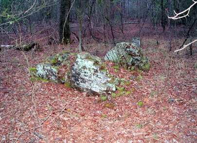
Government gravestone in front of raised brick and mortar vault with arched top, the top collapsed. The 6' vault touches 2nd vault. No dates - dates per public records.
Military Service: American Revolution
Sergt. 5th MD Regt.
Click for more info.
Military Service: American Revolution
Sergt. 5th MD Regt.
Click for more info.
Grave 1
Unmarked Grave
Raised vault with arched top (with the top collapsed) is 4 feet long. Vault touches the vault of Sergt. Samuel Harris.
Grave 2